")
An early look at the 2026 predictions for hurricane season.
By: Christine G. Barlow, CPCU
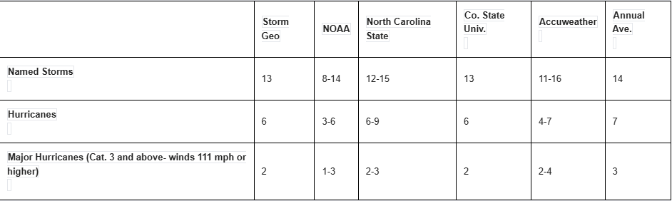
Hurricane season is now just a week and a half away, and NOAA has issued their prediction for the year. Early predictions were made in April, with AccuWeather making the first predictions for 2026, predicting 11-16 named storms, 4-7 hurricanes, 2-4 major hurricanes of category 3 or stronger. Colorado State predicted 13 named storms, with 6 hurricanes and 2 storms of category 3 or stronger. Hurricane season begins June 1 and terminates at the end of November, with the peak between August and October.
New this year from the National Hurricane Center is an operational hurricane track cone that includes tropical storm and hurricane watches and warnings for inland areas. The included areas are the continental United States, Hawaii, Puerto Rico, and the U.S. Virgin Islands. A new alert for the Hawaiian Islands includes storm surge watches, warnings, and peak storm surge graphic. The new storm surge alerts will provide probability-based forecasts of water and storm surge within 72 hours of hurricane impacts, as well as incorporating forecast inputs of storm track, wind intensity, and wind radii. These alerts are publicly available for the main Hawaiian Islands.
What factors determine whether any given year will be an active hurricane season or a quiet one? In general, when the El Niño weather pattern is stronger, the Atlantic hurricane season is quieter. When La Niña is the prevailing pattern, the season is busier. While El Niño directs storms away from land, the warmer temperatures in the Atlantic Ocean associated with La Niña tend to increase the strength of hurricanes, which enables the storms to counteract the effects of El Niño. Colorado State is predicting a weak La Niña transitioning into El Niño over the next few months, with a strong El Niño during peak hurricane season.
Current predictions are pointing to a particularly strong El Niño, which can lead to wetter conditions in some sections of the Americas and drier conditions in South and Southeast Asia, Australia, and Africa. It also suppresses the Atlantic hurricane season. With historically large El Niño’s, temperatures have risen 2 degrees Celsius or more over the norm. This year predictions are that temperatures could raise by 3 degrees. As El Niño tends to peak later in the year, experts are predicting that 2027 will be the hottest year on record.
The names for this year’s storms are as follows:
Arthur, Bertha, Cristobal, Dolly, Edouard, Fay, Gonzalo, Hanna, Isaias, Josephine, Kyle, Leah, Marco, Nana, Omar, Paulette, Rene, Sally, Teddy, Vicky, and Wilfred.
The list of names rotates on a six-year basis, so these names were last used in 2020. Hurricane names are retired from use permanently when a hurricane is considered so deadly or costly that reusing the name would be considered insensitive. For example, the name Andrew will not be re-used due to its devastating effects on Homestead, FL in 1992, which destroyed more than 25,000 homes, leaving 160,000 residents homeless.
Knowing the potential for hurricanes and their devastating effects highlights the importance of preparedness. There are a number of steps people can take to be prepared; the first and arguably the most effective is purchasing flood insurance. There is, however, a 30-day waiting period for policies from the NFIP, so coverage can’t be bought right before a storm. There are some private providers, with shorter waiting periods, but many flood policies are still purchased through NFIP. While the purchase of flood insurance is required in the areas most susceptible to flood, in the last several years hurricanes have been found to move much further inland than
previously thought possible; in any case, the rains generated by hurricanes have flooded areas that had not yet been designated by the NFIP as flood zones requiring coverage. Many other areas are susceptible to flooding from snow melt and rainwater runoff. In these cases, the insurance offered by private carriers should be proactively considered.
Ensuring that the property can weather a storm or any other natural phenomenon is also important. In areas prone to flooding, keeping items off the floor prevents damage to personal property. Having a place to store outside equipment such as patio furniture and grills ensures that they won’t get blown around or damaged by the wind. Having a home inventory is important; there are many apps that make it easier to construct these and even allow for adding photos. A home inventory also helps an insured know that their coverage is set at the
correct amount. Many people underestimate both the value of their personal property and just how much property they have.